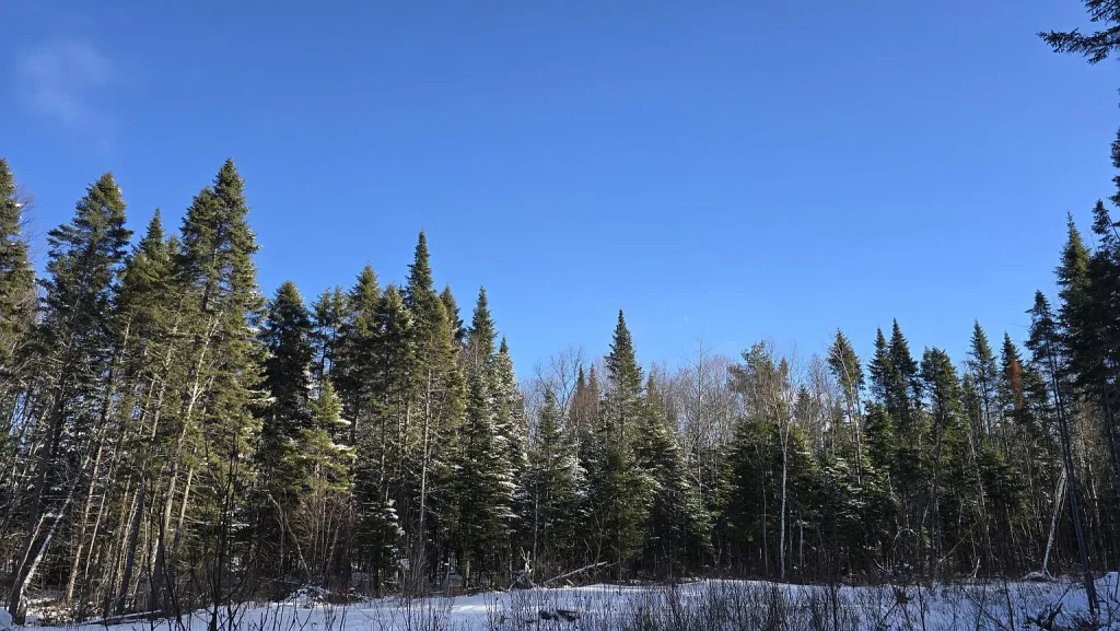
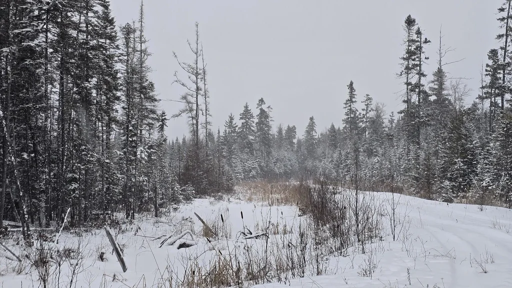
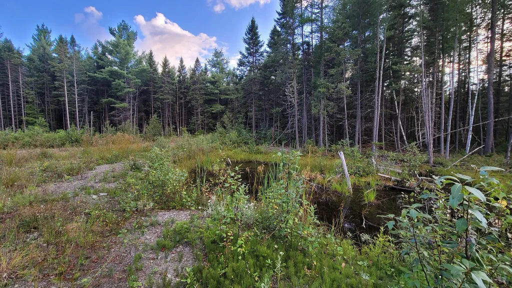
Acquiring 40 acres of dense forestland in New England for $24,900 equating to just $622.50 per acre—appears on the surface to be one of the most extraordinary land bargains in the regional real estate market. Located in the town of Woodland within Aroostook County, Maine (ZIP 04736, Caribou market region), parcel M15L10A along Thomas Road presents a 40- to 44-acre raw timberland tract that is approximately 80% covered by a mature, dense spruce forest.
However, a headline price under $630 per acre carries significant legal and operational realities. The listing disclosures explicitly confirm that the property has no legal access, no recorded right-of-way easement, and no vehicular driveway. Physical entry is available solely via an adjacent rail-to-trail recreational corridor. Furthermore, approximately 33 of the 40 acres are enrolled in the Maine Tree Growth Tax Program, keeping annual property taxes at an ultra-low $341 per year while imposing strict commercial forestry mandates and financial penalties if the land is withdrawn or developed for non-forestry purposes.
This comprehensive real estate analysis deconstructs parcel M15L10A across its financial history, legal access challenges, Maine Tree Growth Tax Law mechanics, timber profile, comparative valuation, target buyer profiles, and essential due diligence steps for prospective purchasers.
Property Overview and Specification Summary
Establishing official listing disclosures, public tax records, and municipal site parameters provides the baseline for evaluating this rural Aroostook County asset.
| Property Parameter | Official Listing Disclosures & Public Records |
|---|---|
| Property Identifier / Address | Parcel M15L10A Thomas Road, Woodland, ME 04736 |
| County / Regional Market | Aroostook County / Caribou Regional Market |
| Current Asking Price | $24,900 (Reduced by $4,100 / 14.1% on May 25, 2026) |
| Original List Price (2026 Cycle) | $29,000 (Listed April 21, 2026) |
| Prior Sale Price (2024 Cycle) | $19,500 (Sold September 11, 2024) |
| Estimated Parcel Acreage | 40.00 to 44.00 Acres (Unsurveyed) |
| Price Per Acre (at 40 Acres) | $622.50 per acre |
| Price Per Acre (at 44 Acres) | $565.91 per acre |
| Price Per Square Foot of Land | $0.0143 per sq. ft. (at 40 acres) |
| Legal Access Status | No Legal Access / No Recorded Right-of-Way Easement |
| Physical Access Corridor | Rail-to-Trail Recreational Corridor |
| Tax Program Enrollment | Approx. 33 Acres Enrolled in Maine Tree Growth Tax Program |
| Annual Property Taxes | $341.00 per year ($28.42 per month) |
| Homeowners Association (HOA) | None ($0.00) |
| Forest Cover Profile | Approx. 80% Dense Spruce Canopy (~32 Acres) |
| Topography & Terrain | Rural, Rolling Slope, Wooded |
| Zoning Classification | Rural |
| Utility Infrastructure | Off-Grid (No Electric, Water, or Sewer Connections) |
| Boundary Survey Status | Unsurveyed |
The Numbers and Detailed Price Analysis
Evaluating a landlocked timber parcel requires analyzing its purchase price per unit, price history trajectory, annual tax liabilities, and baseline land values.
Per-Acre and Land Footprint Calculations
Offered at $24,900 for an estimated 40 to 44 acres, the baseline mathematical metrics yield the following indicators:
- Price Per Acre (Base 40-Acre Footprint): $24,900 ÷ 40.0 acres = $622.50 per acre
- Price Per Acre (Upper 44-Acre Footprint): $24,900 ÷ 44.0 acres = $565.91 per acre
- Total Land Area in Square Feet (40 Acres): 40.0 acres × 43,560 sq. ft. = 1,742,400 square feet
- Total Land Area in Square Feet (44 Acres): 44.0 acres × 43,560 sq. ft. = 1,916,640 square feet
- Price Per Square Foot of Land (40 Acres): $24,900 ÷ 1,742,400 sq. ft. = $0.0143 per sq. ft. (under 1.5 cents per square foot)
In Aroostook County, rural parcels featuring town road frontage, deeded access, and utility drops typically trade between $1,500 and $3,500 per acre depending on timber maturity and soil quality. An asking price of $622.50 per acre represents a discount of 60% to 80% below accessible market averages, directly pricing in the legal limitations of the site.
Historical Price Trajectory Analysis
Reviewing public land records across the 2024 and 2026 listing cycles reveals a history of rapid market entry and price re-indexing:
| Transaction Date | Event Type | Price | Price Per Acre (40 Ac) | Percentage Change |
|---|---|---|---|---|
| July 17, 2024 | Listed for Sale | $37,500 | $937.50 / acre | Baseline Initial List |
| August 28, 2024 | Pending Contract | $37,500 | $937.50 / acre | Contract Executed |
| September 11, 2024 | Sold via Public Record | $19,500 | $487.50 / acre | -48.0% (Below List) |
| April 21, 2026 | Relisted for Sale | $29,000 | $725.00 / acre | +48.7% (Above 2024 Sale) |
| May 25, 2026 | Price Reduction | $24,900 | $622.50 / acre | -14.1% (Price Cut) |
Historical Context Takeaways
- The 2024 Acquisition Baseline: The current seller acquired the parcel in September 2024 for $19,500 ($487.50 per acre), establishing the absolute baseline market transaction price for this landlocked lot.
- The 2026 Resale Margin: At the current $24,900 asking price, the seller is seeking a $5,400 gross markup (+27.69%) above their 2024 purchase price.
- Market Resistance at $29,000: The listing spent 34 days on the market at $29,000 before receiving a $4,100 price cut on May 25, 2026, demonstrating that buyers in the Caribou region enforce strict price ceilings on parcels lacking legal easements.
Tax Assessment Mechanics and Holding Costs
Public tax disclosures for the town of Woodland outline an exceptionally low carrying cost structure:
- Annual Property Taxes: $341.00 per year
- Monthly Tax Carrying Cost: $341 ÷ 12 months = $28.42 per month
- Annual Tax Burden Per Acre (40 Acres): $341 ÷ 40 acres = $8.53 per acre annually
- Effective Tax Rate Relative to Asking Price: ($341 ÷ $24,900) × 100 = 1.37%
- Homeowners Association (HOA) Dues: $0.00 per month
Holding costs of $28.42 per month allow an investor, hunter, or adjacent property owner to maintain title indefinitely with negligible recurring overhead. This low tax load is directly tied to the property’s enrollment in the Maine Tree Growth Tax Program.
The Legal Access Reality: Rail-to-Trail Corridors vs. Legal Ingress/Egress
The most critical factor governing parcel M15L10A is its legal access status. The listing explicitly states: “Property has no legal access… Property is only accessible by rail to trail, there is no recorded easement.”
Understanding the legal and practical distinction between physical access and deeded access is essential for any real estate purchaser.
Key Differences in Access Types
| Dimension | Deeded Legal Easement | Rail-to-Trail Recreational Corridor |
|---|---|---|
| Legal Status | Recorded in County Registry of Deeds | Public Recreational Corridor |
| Enforceability | Enforceable Property Right | Non-Conveyable Access Right |
| Vehicular Use | Fully Permitted for Personal/Commercial Vehicles | Restricted; Non-Vehicular or Seasonal Recreational Only |
| Building Permits | Satisfies Municipal Access Requirements | Rejected by Municipal Code Officers |
| Mortgage Eligibility | Eligible for Conventional/Land Mortgages | Un-Bankable; Cash Purchases Only |
| Infrastructure | Allows Driveway & Utility Extensions | Prohibits Private Utility Installation |
- Absence of a Recorded Easement: A recorded easement is an enforceable legal right registered at the Aroostook County Registry of Deeds that grants a property owner permission to cross another party’s land to reach a public road (such as Thomas Road). Without a recorded easement, the owner has no legal right to cross adjacent private parcels with vehicles, utilities, or heavy equipment.
- Rail-to-Trail Limitations: The parcel borders or rests near a rail-to-trail corridor—a former railroad right-of-way converted into a public recreational path. While members of the public can walk, snowmobile, or ride ATVs along designated trail networks, a rail-to-trail corridor does not grant private vehicular ingress/egress rights for residential access, driveway installation, or commercial logging transport.
- Building Permit Denial: Under Maine municipal land-use guidelines, local code enforcement officers will not issue residential building permits or driveway entry permits for parcels that lack frontage on an accepted public road or a deeded legal right-of-way.
Pathways and Costs for Resolving Landlocked Status
A purchaser seeking to cure the landlocked status of parcel M15L10A faces three potential legal mechanisms, each requiring time and capital investment:
1. Negotiated Easement Purchase from Abutting Landowners
The most direct method is negotiating with an adjacent property owner whose land fronts along Thomas Road to buy a permanent, recorded 30- to 50-foot ingress/egress easement.
- Cost Estimate: Abutters are under no legal obligation to grant an easement. Purchase prices for private access easements typically range from $5,000 to $20,000+, plus land survey and legal drafting costs.
2. Common-Law Easement by Necessity
Under Maine real estate law, if a landowner can prove in court that their parcel was historically severed from a larger parent tract that had road access, a judge may grant an “easement by necessity.”
- Legal Obstacles: Proving unity of title requires an exhaustive historic chain-of-title search dating back decades or centuries. Title litigation in Maine Superior Court can cost $10,000 to $25,000+ in attorney fees with no guaranteed outcome.
3. Prescriptive Easement
Acquiring an easement by prescription requires proving continuous, uninterrupted, adverse, and open use of a specific access route over neighboring land for at least 20 years. Unmaintained, forested landlocked tracts rarely meet these strict evidentiary standards.
Maine Tree Growth Tax Program: Benefits, Rules, and Penalty Risks
Approximately 33 of the 40 acres (82.5%) of parcel M15L10A are registered under the Maine Tree Growth Tax Law (36 M.R.S. § 571 et seq.).
How the Tree Growth Program Operates
The Maine Tree Growth Tax Law was enacted to help landowners preserve commercial forestland by assessing property taxes based on the land’s timber-producing capacity rather than its fair market development value.
- Tax Reduction Mechanism: The state sets annual per-acre land values for softwood, hardwood, and mixed wood timber types. In Aroostook County, tree growth valuations are dramatically lower than residential land valuations, directly resulting in the property’s $341 annual tax bill.
- Statutory Requirement (Forest Management Plan): To remain in compliance, the landowner must maintain a written Forest Management Plan prepared by a licensed Maine professional forester. This plan must be updated every 10 years, documenting that the primary land use is growing commercial timber products.
The Penalty for Program Withdrawal or Non-Compliance
If a new owner chooses to remove the 33 acres from the Tree Growth program—or if the town tax assessor determines the land is no longer being managed for commercial forestry (such as clearing land for a home, farm, or non-timber use)—a mandatory statutory withdrawal penalty is assessed.
Under Maine law, the calculation rule is straightforward:
Withdrawal Penalty = (Fair Market Value – Tree Growth Tax Assessment) × Applicable Penalty Percentage
- 10 Years or Less Enrolled: The statutory penalty rate is 30% of the difference between fair market value and tree growth valuation.
- More than 10 Years Enrolled: The penalty rate is 30% minus 1% per year for each year enrolled beyond 10 years (subject to statutory minimums).
Practical Impact for Buyers
If a buyer attempts to clear the 33 acres for non-forestry use, the town of Woodland will issue a withdrawal penalty bill that can easily reach $3,000 to $10,000+, payable immediately upon removal. Buyers must intend to maintain the parcel as commercial forestland or factor withdrawal penalties into their acquisition budget.
Land Topography, Timber Profile, and Unsurveyed Status
Evaluating the physical terrain and natural resources provides further insight into the parcel’s raw material value.
Forest Composition: Dense Spruce Canopy
The listing disclosures note that approximately 80% of the property is covered by a dense spruce forest.
- Spruce Footprint: 80% of 40 acres equates to roughly 32 acres of solid softwood timber.
- Commercial Utility: Red and white spruce stands in Northern Maine represent valuable timber stock for studwood, dimension lumber, and pulpwood.
- Harvesting Constraint: While 32 acres of spruce timber holds intrinsic stumpage value, harvesting commercial timber requires heavy logging equipment (skidders, log trucks, feller bunchers). Without legal access or a haulage agreement across adjacent lands, commercial logging operators cannot legally transport timber from the parcel to local sawmills.
Topography and Rural Zoning
- Rolling Slope Terrain: The lot is categorized as having a rolling slope. This gentle contour provides natural surface drainage, preventing extensive stagnant water accumulation while offering varied elevated building pockets if access is ever secured.
- Rural Zoning: Governed by Woodland’s rural land-use guidelines, allowing forestry, agricultural activities, off-grid recreational shelters, and traditional land management.
The Unsurveyed Parameter
The listing explicitly states: “Property is approximately 40-44 acres, no survey has been performed.”
- Acreage Variance: The parcel size carries a 4-acre variance (a 10% area fluctuation).
- Boundary Risks: Without a professional boundary survey, property lines rely on historical municipal tax maps (Map 15, Lot 10A). In rural Maine, tax map lines frequently diverge from physical ground boundaries by tens or hundreds of feet.
- Survey Expense: Commissioning a licensed Maine professional land surveyor to mark 40+ unsurveyed, forested acres in Aroostook County typically costs between $3,500 and $6,000.
Utilities, Infrastructure, and Off-Grid Feasibility
Parcel M15L10A represents a 100% unimproved, off-grid land footprint.
- Electrical Infrastructure: Off-grid status. No utility poles or primary power lines serve the parcel. Extending grid power across landlocked terrain without easements is legally prohibited.
- Water Supply System: No water well exists. Residential occupancy requires drilling a private bedrock well or installing a rainwater collection system.
- Wastewater Management: No septic system exists. Installing a septic tank and drain field requires a preliminary Soil Percolation Test (Perc Test) by a licensed site evaluator, alongside legal access for installation equipment.
- Driveway & Parking: Listed as having no driveway and no parking facilities. Vehicles must be parked remotely along public rights-of-way or designated trail staging areas.
Comparative Value Analysis: Subject Property vs. Raw Accessible Land
To measure the value proposition of $24,900, buyers should compare purchasing this landlocked parcel against buying an accessible, surveyed 40-acre lot in Aroostook County.
Scenario A: Subject Property Acquisition (Parcel M15L10A)
- Initial Purchase Price: $24,900
- Professional Boundary Survey (40 Acres): $4,500
- Easement Acquisition from Abutter (Est. Purchase & Legal Fees): $12,000
- Tree Growth Forest Management Plan Update: $1,200
- Initial Gravel Access Track Clearing (500 Feet): $8,000
- ESTIMATED TOTAL CAPITAL TO CURE & DEVELOP: $50,600 ($1,265 per acre)
Scenario B: Raw Accessible Land Acquisition (Hypothetical Market Baseline)
- 40-Acre Parcel with Paved/Town Road Frontage & Deeded Access: $65,000 ($1,625 per acre)
- Existing Boundary Survey: Included
- Existing Road Frontage: Included
- ESTIMATED TOTAL CAPITAL INVESTMENT: $65,000 ($1,625 per acre)
| Financial Metric | Subject Property (Landlocked) | Accessible Land Baseline |
|---|---|---|
| Upfront Purchase Price | $24,900 | $65,000 |
| Initial Capital Outlay | Low Entry Threshold | High Entry Threshold |
| Legal Access Risk | Extreme (No Recorded Easement) | Zero (Public Road Frontage) |
| Total Invested Cost to Secure Access | $50,600 (Est.) | $65,000 |
| Implied Upfront Discount | 61.7% Below Accessible Market | Baseline Market Rate |
Analytical Takeaway
While parcel M15L10A provides a low upfront acquisition price ($24,900), resolving legal access, boundary surveys, forester plans, and road construction absorbs most of the initial savings. If an abutting owner refuses to sell an easement, the parcel remains legally constrained, locking the buyer into an off-grid, trail-only recreational footprint.
Advantages and Potential Drawbacks
An objective real estate evaluation requires weighing property strengths directly against legal and physical liabilities.
Key Property Advantages
- Extremely Low Purchase Price: Offered at $24,900 ($622.50 per acre), providing an entry-level entry point for 40 acres in New England.
- Negligible Tax Carrying Costs: Annual property taxes total just $341 per year ($28.42/month) due to Tree Growth enrollment.
- Substantial Timber Canopy: Approximately 80% covered by dense spruce forest (~32 acres), representing long-term softwood resource value.
- Recreational Trail Proximity: Accessible via a rail-to-trail corridor, providing direct access for ATVs, snowmobiles, hiking, and snowshoeing.
- Rolling Slope Terrain: Natural topographical drainage across a 40- to 44-acre footprint.
Potential Drawbacks and Risk Factors
- Zero Legal Access: No recorded easement or deeded right-of-way; legally unbuildable without acquiring access across neighboring private land.
- No Vehicular Access or Driveway: Cannot bring passenger cars, trucks, RVs, or construction machinery directly onto the site.
- Tree Growth Program Restrictions: 33 acres are enrolled under 36 M.R.S. § 571; non-forestry development triggers severe municipal tax penalties.
- Unsurveyed Boundaries: Lacks surveyed boundary lines, introducing risks of timber trespass or neighbor disputes.
- Un-Bankable Status: Conventional mortgage lenders, FHA/VA programs, and land loan institutions will not finance landlocked properties without a recorded legal right-of-way. Cash capital is required.
Target Buyer Profiles: Who Fits This Property Best?
Matching property characteristics with buyer goals clarifies who can extract utility from parcel M15L10A.
| Buyer Category | Profile Characteristics | Compatibility Fit |
|---|---|---|
| Abutting Landowners | Adjacent property owners along Thomas Road who already hold legal road access and wish to expand their contiguous land holdings at $622/acre. | Ideal Fit |
| Recreational Outdoorsmen & Hunters | Cash buyers seeking an off-grid hunting basecamp accessible by ATV, snowmobile, or foot, content with maintaining 33 acres in Tree Growth. | Ideal Fit |
| Long-Term Speculative Timber Investors | Buyers equipped to negotiate easement acquisitions over several years while maintaining minimal $28/month tax holding costs. | Moderate Fit |
| Traditional Homebuilders & Homesteaders | Buyers seeking to construct a primary home, cabin, or farmstead requiring municipal building permits and driveway access. | Unfavorable Fit |
| Mortgage / Financed Buyers | Purchasers relying on conventional land loans or minimum-down financing. | Unfavorable Fit |
Essential Buyer Due Diligence Checklist
Prospective purchasers should complete the following technical verification steps prior to submitting a cash offer:
- Title Search for Historical Easements: Retain a Maine title attorney to conduct an exhaustive title search at the Aroostook County Registry of Deeds to verify whether any historical access rights exist for Map 15, Lot 10A.
- Abutting Landowner Outreach: Contact neighboring property owners along Thomas Road to assess whether a permanent 30- to 50-foot ingress/egress easement can be purchased.
- Rail-to-Trail Corridor Rule Audit: Consult with the Maine Department of Agriculture, Conservation and Forestry (or local trail management entity) to review rules governing motorized and non-motorized usage along the trail corridor.
- Tree Growth Tax File Review: Review the active Forest Management Plan and enrollment file with the Woodland town tax assessor to confirm compliance status and check when the 10-year forester update is due.
- Surveyor Cost Quotes: Contact a licensed Maine professional land surveyor to obtain a written estimate for surveying and pinning the 40- to 44-acre boundary lines.
Parcel M15L10A on Thomas Road in Woodland, Maine, is a high-risk, high-discount land opportunity. Offered at $24,900 ($622.50 per acre) for 40 to 44 acres of dense spruce timberland, its headline pricing is among the lowest in the state.
Balance of Value
- Strongest Reason to Consider: An exceptionally low entry price paired with $341/year property taxes, making it an affordable recreational foot/ATV retreat or expansion parcel for an adjacent landowner.
- Biggest Reason to Be Cautious: Complete lack of legal access or recorded easement, rendering the property legally unbuildable and un-financially viable for traditional residential use without costly legal intervention.
For an abutting landowner seeking to expand their acreage footprint or an avid outdoorsman looking for an off-grid trail parcel, parcel M15L10A offers a low-cost timberland investment. For traditional homebuilders or buyers requiring drive-in vehicle access, this property should be approached with realistic expectations regarding its legal constraints.

Listed on Zillow